01
Stay close as life changes.
A smaller home for a longtime neighbor. A first place for our grown children. More housing choices can help people stay in East Rockville instead of having to leave.
EAST ROCKVILLE’S NEXT CHAPTER
More housing choices for East Rockville.
Rockville is starting a new East Rockville Neighborhood Plan, replacing the neighborhood’s chapter in the 2040 Comprehensive Plan. This is our chance to shape where new homes belong—and make room for neighbors to stay, downsize, or start out near Metro and Town Center.
Independent advocacy by Ryan Murphy, an East Rockville resident. Not a City of Rockville publication.
WHY THIS MATTERS TO US
More housing choices can make our neighborhood work better for the people already here—and the neighbors to come.
A smaller home for a longtime neighbor. A first place for our grown children. More housing choices can help people stay in East Rockville instead of having to leave.
More neighbors within walking distance means more potential customers for Town Center’s shops and restaurants—and future businesses on Stonestreet.
Homes near Metro make it easier to drive less. Building here can also reduce sprawl, helping address climate change while giving more people access to a place we already value.
EPA: homes, transit & energy [35]FTA: why build near transit? [36]Why hometown housing matters [25]
Keeping the same zoning won’t keep the neighborhood affordable.
A modest house can still be torn down for a much larger “McMansion.” Allowing several smaller homes where they fit gives owners another choice—and gives more households a chance to live here.
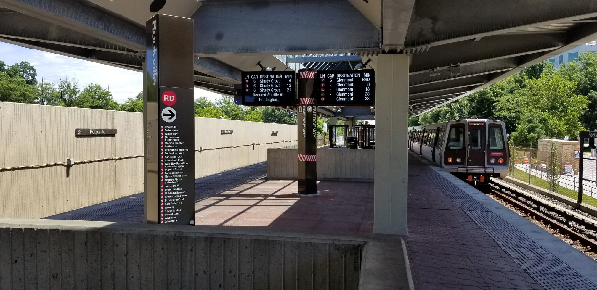
We are close to Metro, MARC, Amtrak, and Town Center, yet most homes are detached houses. Maryland recognized the Rockville station area for transit-oriented development in March 2026. That designation supports the case for more homes near transit; it does not itself rezone any property.
Maryland’s housing report estimates a shortage of 96,000 homes. East Rockville can be part of the solution.
Rockville TOD designation [4]Maryland housing report [3]Existing neighborhood plan [1]
THE PROPOSAL
Larger buildings near the station. Smaller homes on neighborhood streets. Owners choose whether to make a change.
More homes along Stonestreet. More housing choices on neighborhood streets. Owners decide whether anything changes.
Missing-middle change is likely to be very slow. Broad zoning eligibility gives owners options; financing, approvals, and construction still take time. See the local experience and research.
The Metro property keeps its current zoning. The proposal adds capacity beside the tracks, a transition east of Stonestreet, and missing-middle choices on nearby residential streets.
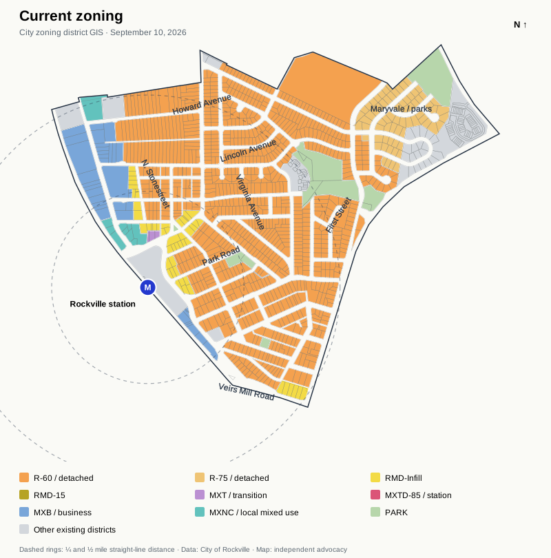
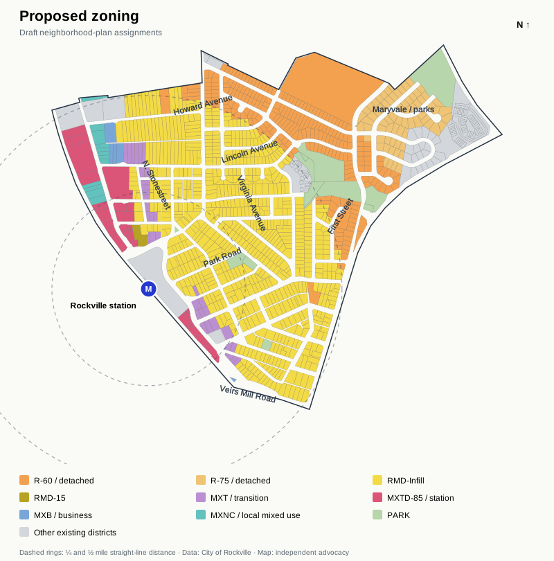
Draft neighborhood-plan map using City of Rockville zoning and parcel boundaries. The city would adopt the final parcel assignments. Tap either map to zoom in.
Rose: MXTD-85 west of Stonestreet. Purple: MXCT east of Stonestreet, north of Metro. Yellow: RMD-Infill. Blue / teal: existing MXB / MXNC. Orange: existing detached-house districts. Green: PARK. Other existing districts retain their assignments.
The maps use the same geography and colors. The Metro property is unchanged. Proposed RMD-Infill covers R-60 residential parcels within approximately ½ mile of the station’s east-side approach; existing RMD-Infill remains. The dashed ring measures straight-line distance, not a walking route. Current parks, identified public/community sites, and other districts retain their zoning. Street-label locations are checked against the saved city parcel addresses and zoning reference map.
Existing overlays and district requirements continue to apply. Final mapping follows complete parcels and includes the city’s site and infrastructure review.
| Where | Proposed zone assignments | What that means for the neighborhood |
|---|---|---|
| West side of Stonestreet, beside the railway | Change existing MXB or MXNC properties to MXTD-85. | More homes and mixed-use opportunities close to trains. Base height: 85 feet. |
| East side of Stonestreet, north of Metro | Change existing MXB or MXNC corridor properties to MXCT. | Homes and neighborhood-serving uses, with a moderate transition toward residential streets. Base height: 75 feet. |
| Residential lots within approximately ½ mile of Metro | Change R-60 residential parcels to RMD-Infill. Retain existing RMD-Infill. | More duplexes, triplexes, eligible fourplexes, townhouses, and cottage courts under existing rules. Generally 30–40 feet, depending on housing type. |
The request: change zone assignments using districts Rockville already has. Keep current building, parking, infrastructure, and review requirements. Preserve parks, public facilities, and existing higher-density districts.
The proposal uses the ordinance adopted June 29, 2026, effective August 1, 2026. It requests map changes only, with no zoning text amendments.
MXB / MXNC → MXTD-85
Assign MXTD-85 to the existing MXB and MXNC properties between Stonestreet and the railway. This existing transit-oriented district supports apartments and mixed-use development near Metro.
More households can live close to trains and Town Center, with the railway on one side of the development area.
West-side Stonestreet properties directly beside the railway; identify complete parcels in the city’s map amendment.
| District | Base height | Existing conditions and bonuses |
|---|---|---|
| MXTD-85 | 85 feet | A 50-foot bonus can allow 135 feet for qualifying projects under Table 7.3.2-1. |
| MXCT | 75 feet | A 30% height bonus can allow 97.5 feet for qualifying state-law projects under Table 7.3.3-1. |
| RMD-Infill | 30 feet: cottage courts; 35: detached homes, duplexes and triplexes; 40: townhouses and eligible fourplexes | 2,000 square feet per home at base; fourplex eligibility under §25.6.3.12(c)(3). Existing conditional density bonus remains available. |
Existing mixed-use setbacks and upper-story transitions apply where required by §§25.7.3.6–7. All use conditions, parking, tree, stormwater, historic, infrastructure, and development-review requirements continue to apply.
Under RMD-Infill, a 6,000-square-foot lot has enough base lot area for three homes. An 8,000-square-foot lot has enough base area for four homes, with a fourplex also needing to qualify under §25.6.3.12(c)(3). Layouts must meet the district’s other requirements.
The plan can recommend suitable corner lots for fourplexes under the existing corner-lot provision.
Current zoning ordinance [7]Official zoning map & guide [8]City development review [27]
Ask the city to test housing capacity and infrastructure needs under these assignments. The calculator’s 500- and 1,000-home scenarios are illustrations for that discussion. Aim to complete map changes within a year of plan adoption, following the required public process.
WHAT THESE HOMES LOOK LIKE
Familiar housing types, with more than one way to live in the neighborhood.
“Missing middle” just means more options between a detached house and a large apartment building.
RMD-Infill is likely to bring very slow, property-by-property change. In 2021, 16 properties near Metro on Park Road, England Terrace, and Reading Terrace were rezoned to RMD-Infill. As of September 2026, five years later, none has completed redevelopment under that zoning.
Separately, GCAAR–HR&A analyzed the proposed 2026 zoning changes—not the 2021 rezoning above. Its study of 458 parcels proposed for RMD-Infill projects just 21 net new homes over ten years—about two net additions per year. The model projects redevelopment of 55 existing homes over that decade, leaving most properties unchanged.
That is a reason to allow missing middle broadly. Most owners will keep their homes as they are. More eligible properties give the small share who choose to build a chance to add the homes our neighborhood needs.
GCAAR: 21 homes over ten years [44]Read the full GCAAR–HR&A study [45]
Duplexes, triplexes, and eligible fourplexes can share a building without the scale of a large apartment complex.
Attached homes with their own entrances offer another way to own a home while sharing less land per household.
On suitable sites, smaller homes can offer an easier place to maintain or a first home near friends and family.
Smaller homes can offer less expensive choices than a large new detached house. They won’t all be affordable to everyone, so income-restricted housing and assistance still matter.
Minneapolis: missing middle [28]NYU research review [10]
Minneapolis: its 2020 reforms allowed up to three homes on residential parcels. The city also identifies financing and building requirements as challenges to getting homes built.
Minneapolis: missing middle [28]
Portland: its 2021 Residential Infill Project expanded opportunities for duplexes, triplexes, and fourplexes, with a six-home option tied to affordability requirements.
Portland: 2021 infill reform [29]Portland: housing options today [30]
Cambridge: its 2025 changes allowed multifamily housing citywide, including buildings larger than typical missing-middle homes.
These examples show different approaches. Our proposal uses Rockville’s existing districts; it does not ask the city to copy these ordinance changes.
A STRONGER TAX BASE
New homes bring new taxpayers as well as new service needs.
More homes can help support the services we all use.
For illustration, 500 additional homes could generate about $686,000 a year in added city property tax once built, under the assumptions below. That is additional revenue to help support our shared services, before service costs and tax credits.
Presets reset the assumptions below.
ADDITIONAL ANNUAL CITY PROPERTY TAX
AT FULL COMPLETION, BEFORE COSTS & CREDITS
600 new homes replace 100 existing homes: 500 net additional homes.
Estimated additional city property-tax revenue, before service costs, capital costs, and tax credits.
Rockville lists a city real property-tax rate of $0.292 per $100 of assessed value. That equals 0.00292 dollars of annual city tax for each dollar of taxable assessment. County, state, and special-district taxes are not included.
Annual added city tax = [(net added homes + homes replaced) × new assessment per home − homes replaced × existing assessment per home] × 0.00292
Default: [(500 + 100) × $500,000 − 100 × $650,000] × 0.00292 = $686,200 per year. The assessments are editable scenario assumptions, not appraisals, sale-price estimates, or observed averages. The 500-home scale is a proposed alternative for staff to test.
The cumulative figure assumes uniform completion from the beginning to the end of the selected period, with partial-year taxation approximated continuously: full annual revenue × years ÷ 2. It uses constant 2026 dollars, no appreciation, no discounting, and no construction-period loss of the old tax base. It is not an immediate annual windfall.
| Net added homes | Existing homes replaced | Total new homes | Added annual city tax |
|---|---|---|---|
| 250 | 50 | 300 | $343,100 |
| 500 | 100 | 600 | $686,200 |
| 1,000 | 200 | 1,200 | $1,372,400 |
These are illustrations of tax arithmetic, not a determination that any number of homes fits on a particular site. A corridor redevelopment, vacant parcel, and infill replacement have different existing tax bases. Commercial space is excluded.
Compact growth can use infrastructure more efficiently, but services are not free. Test an assumed annual city operating cost per net additional home below. This is a sensitivity input, not a cost estimate. County schools and other county services require a separate analysis against county revenues.
Enter a cost to compare it with the current gross revenue scenario.
At the default assumptions, gross additional city property tax is $1,372.40 per net added home annually. Operating costs above that amount would exceed this one revenue source, before capital costs. This threshold is not the city’s actual marginal cost and excludes other possible revenues.
Parcel-level existing assessments; the taxable value of different housing types and MPDUs; construction timing and demolition; state assessment phase-ins; exemptions, abatements, and any payment-in-lieu-of-tax agreement; city operating costs; utility and transportation capacity; capital financing; and the county’s school and service costs.
Public land or subsidized projects may have different tax treatment. Enterprise-zone eligibility or other incentives do not guarantee a particular tax credit on a particular property. Residential assessments cannot simply be substituted for an existing industrial or commercial tax base.
More homes can strengthen the budget and spread the cost of shared services across a larger tax base.
LET’S TALK ABOUT IT
Start with the questions on your mind.
No. This proposal calls for willing owners to choose whether to redevelop. It does not call for eminent domain. Homeowners can keep their homes and continue living in them; rezoning creates options, not an obligation to sell.
No—RMD-Infill change is likely to be very slow. In 2021, 16 properties on Park Road, England Terrace, and Reading Terrace were rezoned to RMD-Infill. As of September 2026, five years later, none has completed redevelopment under that zoning. Separately, the GCAAR–HR&A study analyzed the proposed 2026 zoning changes, not those 2021 rezonings. For the 458 parcels studied, it projects 21 net additional homes over ten years, with 55 existing homes redeveloped over that decade. Owners still need a workable project, financing, approvals, and construction, and most will keep their homes as they are. Broad eligibility matters precisely because only a small share of owners will build. Larger Stonestreet projects are a separate part of this proposal.
GCAAR: 21 homes over ten years [44]Read the full GCAAR–HR&A study [45]2021 rezoning ordinance [5]Current zoning ordinance [7]
New homes help even when their first residents pay market rates. Each additional home gives a household another option instead of competing for an existing one. Research finds that new supply can ease rent pressure, and moving chains open up homes elsewhere in the market. Rockville’s existing affordable-housing requirements provide another way to include below-market homes in qualifying developments.
NYU research review [10]Original moving-chain study [40]Rockville affordability tools [22]
Yes. More smaller homes nearby can let seniors downsize without leaving friends, familiar places, and the community they helped build. Apartments with elevators and accessible layouts offer alternatives to maintaining a large house and yard. More housing choices mean more ways to stay in East Rockville as life changes.
Current parking requirements continue to apply, and reductions require approval under the existing ordinance. Locating homes near Metro, shops, and services also gives residents more ways to get around without a car. Managing curb space for visitors, accessible parking, and loading can help make existing street space work better.
Location makes a difference. Research shows that compact neighborhoods near transit can support less driving per household than development farther from jobs and services. East Rockville already has Metro, MARC, and Amtrak. Pairing more homes with safer crossings and sidewalks makes better use of those connections.
Rezoning keeps Rockville’s infrastructure safeguards in place. Under the Adequate Public Facilities Ordinance (APFO), projects that require an adequate-facilities determination must show that public facilities can support them. Applicants must mitigate adverse impacts to meet the city’s standards; water and sewer adequacy is confirmed before a building permit. The neighborhood plan should identify school, utility, transportation, park, and emergency-service improvements alongside new homes. More residents also help fund the services we share.
More housing does not automatically mean lower property values. An Urban Institute study in nearby Alexandria found a small positive association between affordable housing and surrounding home values. Additional redevelopment options can also add value to land, while more neighbors help support the shops and services that make a neighborhood desirable.
Our neighbors, parks, porches, and everyday connections are part of that character. More housing choices can help people stay. Keeping detached-home zoning can still mean teardowns for large McMansions. This proposal puts larger buildings near the station and more modest homes on residential blocks, with existing protections still applying.
The evidence does not support treating apartments as an automatic source of crime. Research on Low-Income Housing Tax Credit developments found crime reductions in low-income neighborhoods. Good lighting, maintenance, and responsive management are practical ways to support safety as a neighborhood grows.
Some households already share detached homes: an ERCA survey respondent described several households living in individual houses. Giving people more separate homes offers an alternative when sharing is driven by a lack of affordable choices. More front doors can meet needs that already exist in the neighborhood.
Homes near trains and shops make it easier to drive less and reduce pressure to build farther out on undeveloped land. Smaller homes and shared walls also use energy more efficiently. Allowing compact homes here puts housing and climate action in the same place.
EPA: land use & travel [17]EPA: homes, transit & energy [35]Housing & climate [33]
The proposal keeps public parks and existing tree and stormwater requirements in place. Compact homes within an established neighborhood can also reduce pressure to develop forests and open land farther out. Growing near our trains lets more people share the parks and green spaces we already value.
Current and future neighbors gain more housing choices, opportunities to downsize nearby, and a stronger customer base for local shops. More homes can help our grown children find a place of their own and help longtime residents stay connected to the neighborhood.
People do not have to give up their cars to benefit. Living near trains, shops, and services makes it possible to replace some car trips with walking or transit—and can give households more flexibility about how many cars they need. Every convenient alternative expands residents’ choices.
Town Center should grow too. Both sides of the station are good places for more homes. A wider range of suitable sites and housing types gives the city more opportunities than relying on a few large projects.
Yes. The new neighborhood plan gives residents a direct opportunity to shape East Rockville’s future. ERCA’s survey already found substantial support among respondents for options that include missing-middle housing. Share the homes, services, and walking connections you want the city to make possible.
WHY I SUPPORT THIS
The short version is here. The sources are one click away.
More homes can ease competition for the homes we already have.
Research supports adding supply alongside help for households who need affordable homes now. Allowing more homes near our trains is a practical step we can take locally.
NYU research review [10]Minneapolis Fed: moving chains [12]
In ERCA’s 2024 survey, roughly 64% of respondents chose options including missing-middle homes within ¼ mile of Metro, and roughly 60% did so in the outer walking area.
ERCA reported 114 valid responses and 45 written comments in its 2024 neighborhood survey.
ERCA’s 2024 report records 114 valid responses and 45 written comments. Roughly 64% of respondents chose options including missing-middle housing within ¼ mile of Metro; roughly 60% did so in the ¼–½-mile ring.
| Selected option | Within ¼ mile | Over ¼ to under ½ mile |
|---|---|---|
| Keep the 2040 plan’s proposed limits | 36.2% | 40.5% |
| Add missing middle: duplexes, triplexes, or rowhomes | 19.0% | 31.0% |
| Also allow small apartment buildings | 19.0% | 19.8% |
| Also allow large apartment / mixed-use buildings | 25.8% | 8.6% |
Source: report pages 2–5. The roughly 64% and 60% figures combine the last three options, which all include missing middle; the table shows the distinct levels of support for each housing option.
The practical takeaway: make missing-middle housing a central part of East Rockville’s next chapter.
Showing all 45 sources.
City of Rockville
The starting point for this update. Page 264 reports 1,028 detached homes, 65 attached homes, and six apartment/condominium units. Page 270 dates MXB zoning in the two A4 Stonestreet areas to 2009. Pages 272–273 describe 50–65-foot buildings near Park Road and limited infill recommendations. These are historical figures, not a 2026 housing inventory.
Engage Rockville
The city is beginning a new plan to replace the Planning Area 2 chapter. Use this page for participation opportunities and current announcements; meeting dates may change.
Comptroller of Maryland
Page 24 describes a 96,000-home shortage and a need for nearly 30,000 homes annually, compared with 16,000–19,000 permits annually since 2013. Pages 35–50 examine land, zoning, parking, approvals, and construction costs. Permits and completed homes differ.
City of Rockville
Confirms designation of the station area, its three rail services, and eligibility for state assistance. The designation itself does not rezone property or approve a project. Its boundaries are not identical to the neighborhood boundary.
City of Rockville
The signed ordinance and attached maps document the Stonestreet-area rezoning. PDF page 4 provides the adoption date; the map sheets show the limited RMD-Infill area. The map sheets are the official record of the 2021 zone assignments.
Applicant submission hosted by City of Rockville
Describes a proposed eight-rowhouse replacement for one detached home in the RMD-Infill zone. It establishes that a proposal existed; it does not establish approval, construction, or completion.
City of Rockville
Relevant provisions: §25.6.3.12 (multiplex eligibility), §25.7.1.5–7 (infill and medium-density zones), §25.7.3.2–5 (mixed-use districts), Division 8.2 (parking), and Division 8.11 (adequate public facilities). Tables give base standards; other use rules, bonuses, overlays, and site requirements also apply.
City of Rockville
Use the city’s live zoning map to identify the designation of an individual property. The comparison uses city GIS boundaries to show current zoning and a proposed neighborhood-plan map.
City of Rockville
Rockville’s listed real property-tax rate is $0.292 per $100 of assessed value, or 0.292%. This is the city portion only. The calculator uses this rate and hypothetical assessments, not current sale prices or a parcel appraisal.
Vicki Been, Ingrid Gould Ellen & Katherine O’Regan · NYU Furman Center
Reviews recent evidence on supply, rents, moving chains, and displacement. The evidence favors adding homes while recognizing that market supply alone cannot meet the needs of the poorest households.
Asquith, Mast & Reed · Upjohn Institute
Studies large market-rate apartment buildings in low-income areas. The working-paper abstract estimates nearby rents 5–7% below the comparison outcome. The findings show how new homes can relieve competition for existing rentals.
Federal Reserve Bank of Minneapolis
Explains how households moving into new apartments free up homes elsewhere, including in lower-income neighborhoods. New market-rate housing and targeted housing assistance can serve complementary roles.
Greenaway-McGrevy & Phillips · Journal of Urban Economics
The authors’ preferred model estimates 21,808 additional dwelling permits in the five years following broad 2016 upzoning. Permits are not completions or net additions after demolition; the estimate depends on the comparison model.
The Pew Charitable Trusts
For 2017–2022, Pew reports 12% housing-stock growth and 1% rent growth in Minneapolis, versus 4% and 14% in the rest of Minnesota. Multiple reforms and market conditions overlap; the comparison does not isolate the effect of one zoning change.
Christina Plerhoples Stacy & Christopher Davis · Urban Institute
A repeat-sales analysis finds a small positive association with nearby home values. Design, management, and local oversight may matter. This is evidence against assuming that more housing automatically reduces nearby property values.
Rebecca Diamond & Tim McQuade · NBER / Journal of Political Economy
Research on Low-Income Housing Tax Credit developments finds reduced crime and higher home values in low-income neighborhoods, with different property-value effects in higher-income areas. Subsidized housing results should not be generalized to every apartment project.
U.S. Environmental Protection Agency
Reviews connections among land use, transportation, and environmental outcomes. Compact development, transit access, and connected streets can reduce driving per household. That does not imply no added traffic at a particular intersection.
U.S. Environmental Protection Agency
Explains how compact development can use infrastructure more efficiently and strengthen a local tax base. Local infrastructure condition, capacity, service costs, and financing still determine the fiscal result.
Greater Greater Washington
A useful explanation of the “luxury” label and the distinction between new construction, marketing, and affordability. Commentary provides context; use the empirical studies for causal evidence.
American Planning Association · Planning
Discusses how mandatory parking raises development costs and constrains usable land. Background research, not a request to amend Rockville’s parking standards; this proposal uses only existing parking provisions.
Mercatus Center
Examines how lot-size rules constrain housing options. Useful context for choosing existing districts that fit neighborhood parcels and recognizing where minimum site areas require voluntary assembly.
City of Rockville · HR&A Advisors
Describes Rockville’s 15% MPDU requirement in qualifying developments and opportunities to improve affordable-housing delivery. The draft also identifies market obstacles to rental construction and MPDU delivery. Its recommendations are not themselves an adopted ordinance.
City of Rockville
Documents the June 29 adoption and August 1 effective date. This website uses the resulting code rather than treating older draft standards as current.
Ryan Murphy · Ryan in Rockville
Background on the request to revisit East Rockville’s planned land use: Ryan Murphy’s June 2024 appeal to Mayor and Council sets out the case for revisiting the neighborhood’s land-use plan. The current proposal uses existing zoning districts and their adopted standards. Historical figures in this background post are not current estimates.
Washington Monthly
A personal account of being priced out of one’s hometown. Useful for the human stakes of housing choices, rather than as a causal evaluation of a completed reform.
Maryland General Assembly
Adds transit-area provisions on parking and mixed uses, subject to exceptions including land zoned single-family on January 1, 2026. This helps explain why local action on East Rockville’s detached-home zones remains essential. Site-specific application requires city review.
City of Rockville
Explains the stages between an idea and a development decision. Different application types have different paths. A neighborhood plan, rezoning, application, permit, and completed home are separate milestones.
City of Minneapolis
Explains modest multi-home buildings, the change allowing three homes on residential parcels, parking reform, and remaining building-code and financing obstacles. Policy adoption alone is not evidence of a particular rent effect.
City of Portland
Documents duplex, triplex, and fourplex reform with building-scale limits, plus a six-home affordability bonus requiring half the homes to serve households at up to 60% of median family income.
City of Portland
Describes multiplexes, cottage clusters, parking reform, and land divisions that can support separate ownership. Lot sizes, hazards, street access, and building standards constrain eligibility; all options do not apply to every lot.
City of Cambridge, Massachusetts
Describes citywide multifamily reform, four-story Residence C-1 buildings and conditional six-story permission, and removal of minimum lot size, unit-count, and floor-area caps for housing. A policy comparison, not a measured affordability outcome.
East Rockville Civic Association
The linked report states 114 valid responses and 45 written comments on page 2. Pages 3–5 show roughly 64% selecting missing-middle or denser options within ¼ mile and roughly 60% in the ¼–½-mile ring. The full table shows preferences for each housing type. Page 14 includes a resident comment about multiple households sharing detached homes.
Josephine A. Phillips · The Regulatory Review
Explains the connection between sprawl, driving, and emissions, while cautioning that looser zoning alone does not guarantee compact development. Its argument favors deliberate attention to where additional housing is built; it is not a forecast of East Rockville’s emissions.
The Pew Charitable Trusts
Compares Minneapolis, New Rochelle, Portland, and Tysons with the national rent trend. Places that expanded housing experienced much slower rent growth over 2017–2023. A readable introduction to how zoning, supply, and rents connect.
U.S. Environmental Protection Agency
Shows why both location and housing type matter: transportation choices reduce energy use and household costs, while compact multifamily homes gain efficiency from smaller sizes and shared walls.
Federal Transit Administration
Explains how walkable mixed-use development near transit supports housing, ridership, local businesses, air quality, and pedestrian access. A useful guide to why station areas deserve more housing choices.
Shane Phillips, Michael Manville & Michael Lens · UCLA Lewis Center
Reviews six early studies: five find affordability benefits from new market-rate housing and one finds mixed results. Explains why a new building’s high asking rent does not mean it raises rents in the homes around it.
Miriam Zuk & Karen Chapple · UC Berkeley
Supports building market-rate and subsidized homes alongside preserving affordability. The Bay Area analysis finds a particularly strong regional protective role for subsidized housing, reinforcing the case for adding homes and helping existing residents together.
Edward Glaeser & Joseph Gyourko · Federal Reserve Bank of New York Economic Policy Review
A foundational study of why home prices in expensive places exceed construction costs. Identifies zoning and other restrictions on building as a major part of that gap in high-cost markets.
Evan Mast · Upjohn Institute
Tracks the address histories of 52,000 residents of new buildings. Moving chains quickly reach lower-income neighborhoods, showing how new construction can free up existing homes across the housing market within years.
Smart Growth America / Form-Based Codes Institute
Documents how a train-connected suburb used resident input and zoning reform to support new homes, arts space, and downtown investment. An example of turning a community vision into development opportunities.
Emily Hamilton · Mercatus Center
A nearby example of allowing housing on commercially zoned land around Metro. Finds substantial progress on housing construction and highlights the importance of pairing added homes with better pedestrian connections.
City of Rockville GIS
Zoning Districts layer 8 and Comprehensive Plan Planning Area layer 3 supply the comparison’s current district boundaries and neighborhood outline. Parcel outlines come from the city’s Rockville_Property_WebMerc service. Proposed assignments are this website’s draft.
Greater Capital Area Association of REALTORS® · study commissioned from HR&A
Reports a projection of 21 net new homes over ten years under the market conditions and proposed Rockville zoning-rewrite standards studied by HR&A. The estimate illustrates modest expected production from that proposal; it is not a forecast of this site’s broader rezoning plan.
HR&A Advisors · commissioned by GCAAR
Studies 458 parcels proposed for RMD-Infill in the draft 2026 map amendment (page 14). Its ten-year model projects 55 existing homes redeveloped and 76 homes built, yielding 21 net additions (pages 7 and 9). The analysis connects gradual production to property turnover and project economics. Its scope excludes larger mixed-use projects.
Research reviewed September 11, 2026. Explore original studies, accessible explainers, and local planning documents above.
MAKE YOUR VOICE HEARD
Tell the city you support more housing choices in East Rockville.
Ask for more homes near Metro, modest infill on suitable neighborhood blocks, and practical improvements to streets and services.
We can welcome more neighbors while giving the people already here more ways to stay.
Visit the city’s project page for updates and ways to participate.
WHY I MADE THIS PAGE
An East Rockville neighbor on Virginia Avenue, a few blocks from Metro.
I’m not a developer or a landlord, and I’m not pursuing a financial gain from changes to land use. I made this page because I care about making housing more affordable.
I want our neighborhood to offer more ways for people to stay, put down roots, and enjoy living near our trains, shops, and parks.
Questions or comments? I’d love to hear from you. Email me at ryaninrockville@gmail.com.
Background: my 2024 request to revisit the neighborhood plan ↗